


A Short(ish) History of Lambeth 1720-1899
I'll take a different tack with this page and start this journey 120 years before any Partleton puts a foot into Lambeth.
Since this page is not dedicated to one individual, it has less human interest in it than usual - sorry about that - but I will try to sprinkle a some context of the Partleton family's story into it.
The earliest useful map I could find is this 1720 Survey of the Cities of London and Westminster by John Stow. We don't yet know of any Partletons in Lambeth, or indeed in London or at this date:

The alleyway circled in the above map is Cockets Alley which goes by numerous similar names during its life, and is also known as Duke's Head Court after the pub at its junction with Fore Street. Cockets Alley is numbered 30 in the key, though it's hard to read the number on the map because it is squashed in sideways . At this time - 1720 - Lambeth is plainly a village: these little houses are quaint; rural. It will be a long time - 130 years - before a Partleton (James b1806) moves in to Cockets Alley, and before this happens, the courtyard will have become an overcrowded unsanitary slum, as we shall see.
In 1746, the date of the next map, which was created by French immigrant and London resident John Rocque, the first thing to note is that there are no bridges at Lambeth or Vauxhall. There isn't even a bridge at Westminster to the north until 1750:
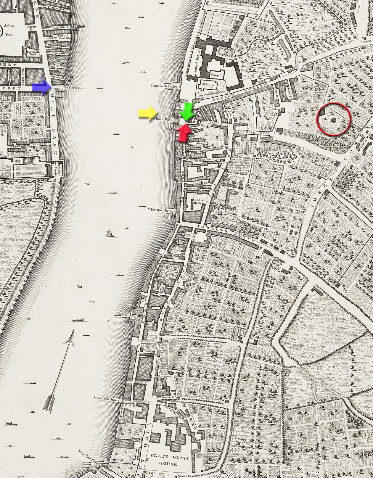
Crossing the river in this part of London was by boat only, which is why we see a small armada rowing directly across the river rather than along its length. If you had a horse or carriage, you had to use the horse ferry next to Lambeth Palace.
Below, captured in time by artist John Varley in the early 1800s, we see the horse ferry from Millbank to Lambeth, with St Mary-at-Lambeth church and the archbishop of Canterbury's London residence, Lambeth Palace, in view on the opposite bank. The artist's viewpoint is from the blue arrow in the map above.
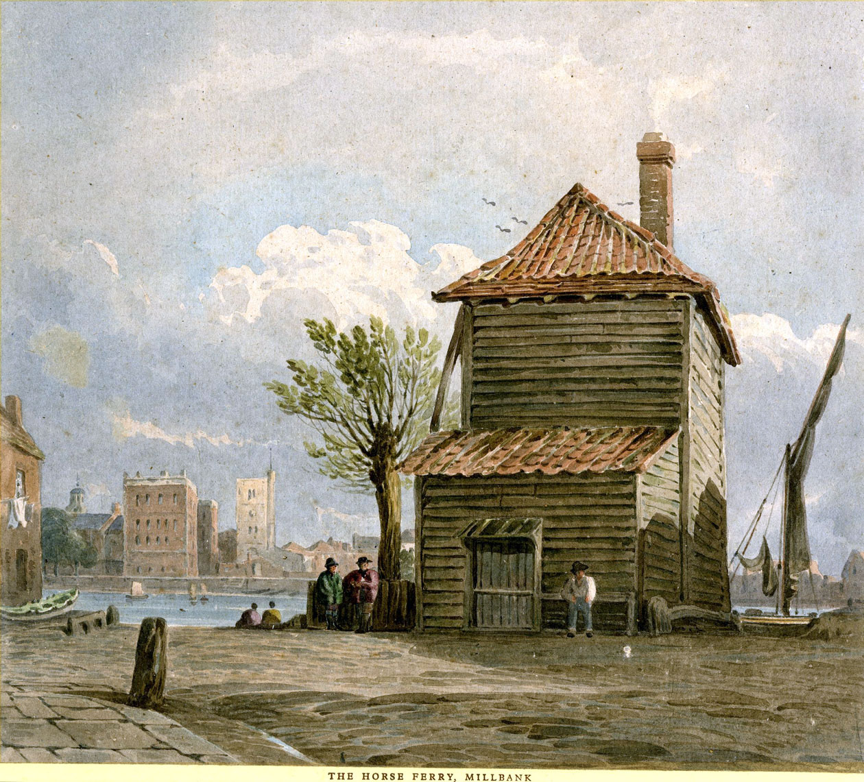
We get exactly the same view of this river crossing in the image below, by engraver 'WP' whom I believe is William Henry Prior.
Both images contain identical elements such as the saiboat on the right and are therefore different versions of the the same picture. The engraving below was created at a later date based on the watercolour painting above, at which time Mr 'WP' has taken a few liberties; artistic license.
A farmer and his wife wait for their wagon, and - it seems - a haystack, to be transported across the Thames:

The road where the artist stood at Millbank in 1800 is still called Horseferry Road today.
In the next image, engraved in 1708, we see the ferry actually in action, with horses and a carriage on board, circled in yellow. The ferry is near Lambeth Stairs outside the Palace. But that large fancy carriage obviously didn't jolt its way down Lambeth Stairs. It had boarded the ferry at Horse Ferry Lane, a few yards out of the picture to the right on the Lambeth shore:
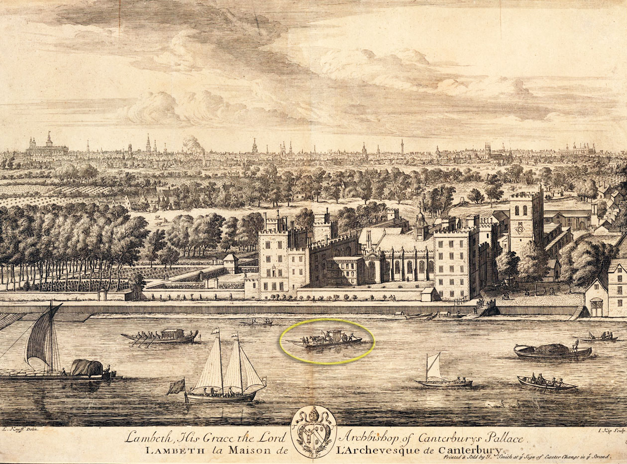
The beautiful engraving above was created by Dutchman Jan Kip with the help of his associate and fellow Dutch draftsman Leonard Knyff. It was published in 1708 as a part of their great work Britannia Illustrata.
Kip had worked for William of Orange in the Netherlands and had followed him in the 1690s to London after William and his cousin Mary were invited to England in 1693 to become co-regents in the glorious revolution.
The aerial perspective in Kip's drawing was created entirely by dint of imagination - there was no way for him to actually get up in the air: the engraving pre-dates hot-air balloons by 75 years. I've placed a full-size copy below for the gentle reader to enjoy the beauty of Kip's detail of the marshy farmland of Lambeth, with the built-up and busy backdrop of the north side of the Thames in the distance:
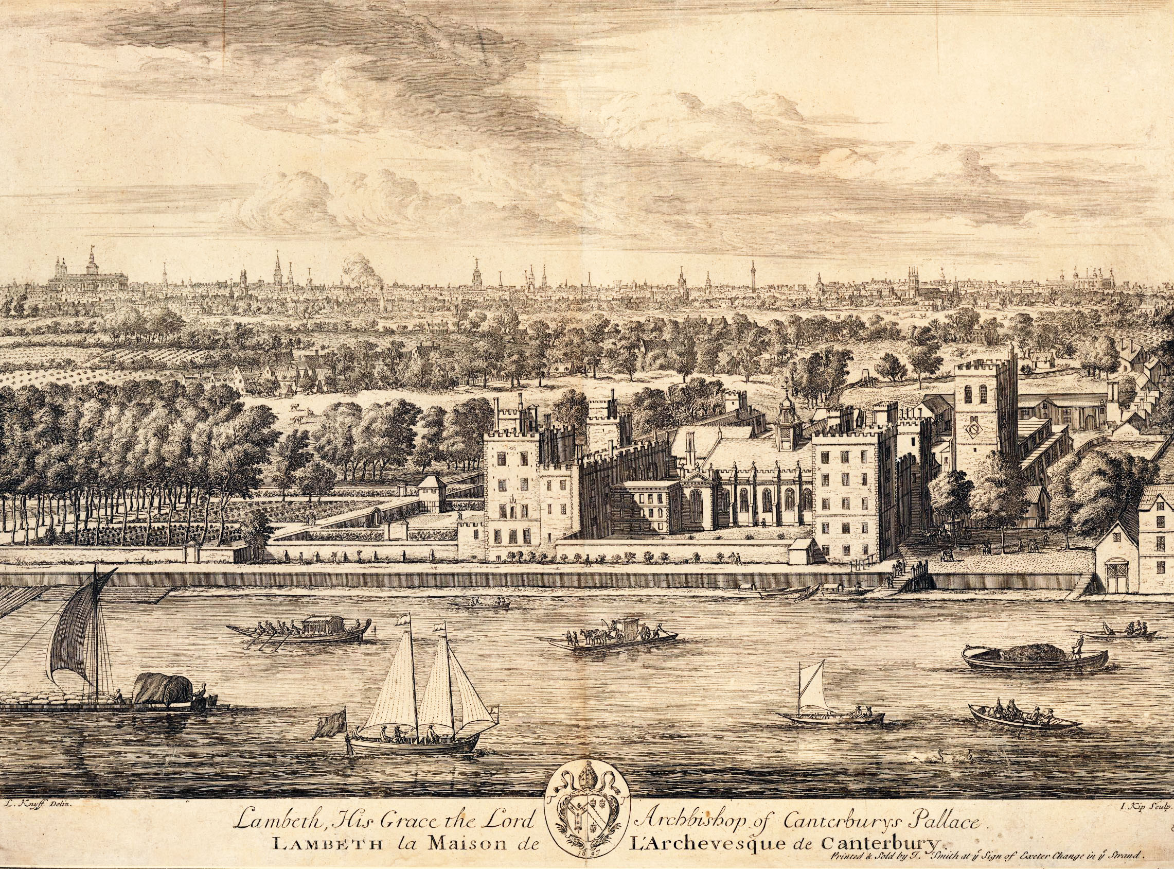
Kip's picture certainly makes it clear just how rural Lambeth was.
Let's have a close-up look at that ferry:
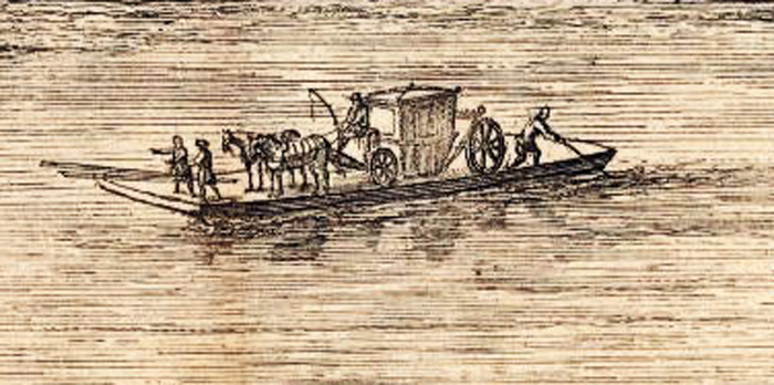
We see that it is transporting a carriage with two horses still fully harnessed. The carriage has obviously simply rolled-on to the ferry; the horses are trusted to behave themselves during the voyage, and the carriage will roll-off again at its destination. It's also apparent that the ferry, with its flat bottom, was not the most stable of all vessels. It's not clear how it was propelled but it looks like the fellow at the back might be punting it with a pole. The Thames is not massively deep at this stretch, and indeed may have been forded from Lambeth at low tide in ancient times when the river had been wider. There are also spare poles or possibly oars on the deck; no-one is rowing.
Anyhoo, with nervous horses on board, and often heavily-laden, sometimes on a choppy river, it should be no surprise that there are records of numerous notable occasions when the ferry capsized or sank.
In 1633, in the reign of king Charles I, William Laud had been delighted to be appointed as the new Archbishop of Canterbury. On the day before his inauguration, he made arrangements for his servants and horses to be transported across the Thames to his new home at Lambeth Palace, by means of the Lambeth ferry, as recorded in his diary entry of 19 September 1633:

Sixteen years, and two civil wars later, things had changed. The idiot Charles I had thought that he was divinely ordained by God to rule Britain. Imagine his surprise, at his execution in 1649, when he discovered that he wasn't.
Britain consequently become a republic in 1649 with Oliver Cromwell at its head as Lord Protector.
But Oliver was also to experience the risks of the Lambeth ferry crossing, as we read in a letter of March 1656 from Dutch ambassador Willem Nieupoort to his masters back in Holland:
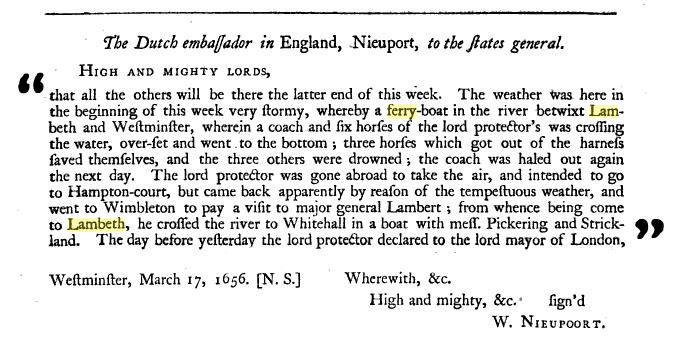
The river may not have been deep, but it was deep enough to drown in. Three of Cromwell's horses were less lucky than Laud's, the unfortunate beasts being dragged to the bottom because they were harnessed to the carriage.
It is noticeable in ambassador Nieuwpoort's letter that the ferry and boat-crossing at Lambeth was very important before 1750, at which time the only bridge across the Thames was London Bridge.
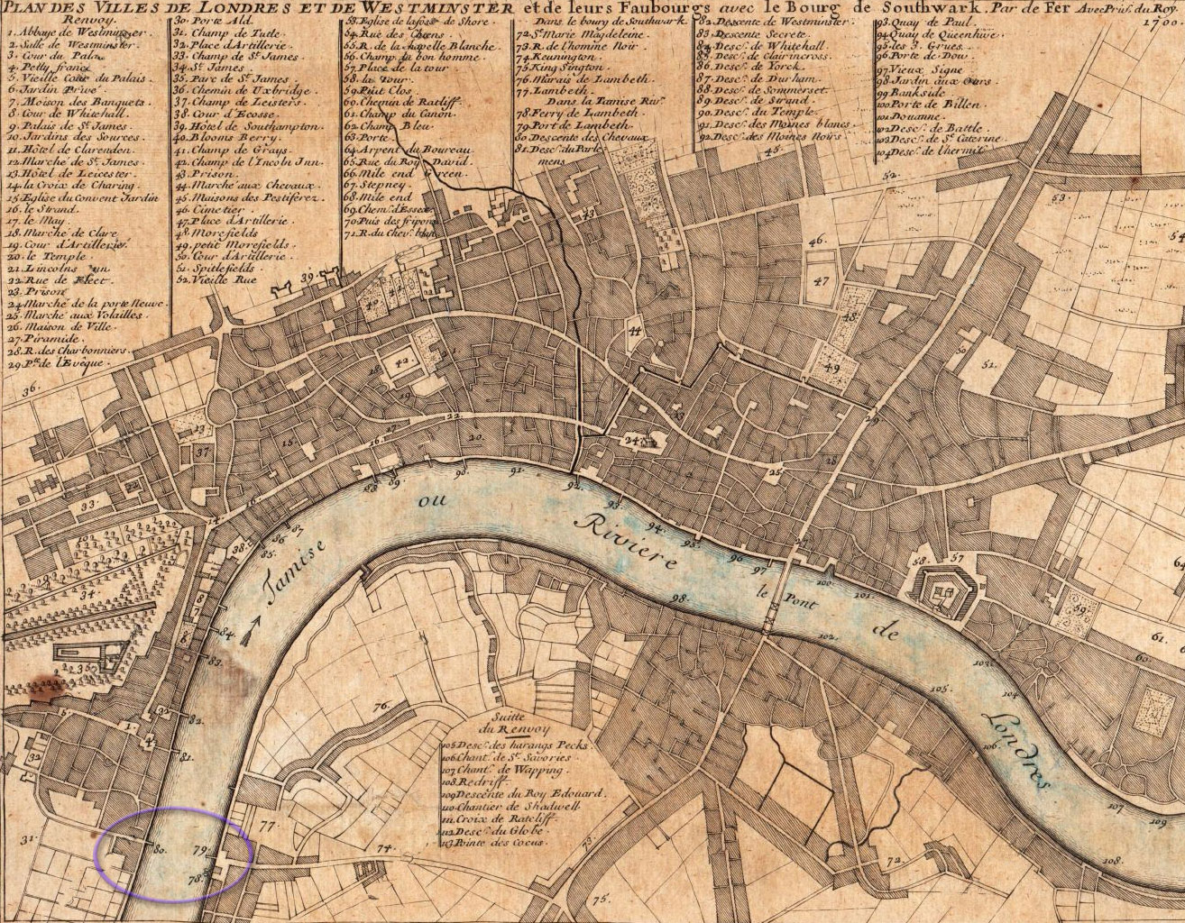
These two incidents were recorded for posterity because the owners were famous, but I think they inform us that incidents on the ferry must have been quite commonplace. If we look at Charles Inselin's 1720 map, wherein we see only one bridge, it is obvious why the ferry at Lambeth, circled at the bottom left, was so popular:
If they hadn't ended up in the drink, Archbishop Laud's and Oliver Cromwell's men and horses would have landed at Horse Ferry Lane on the Lambeth bank, at the point of the red arrow in the map below, which is long gone in modern times:

We know exactly what Horse Ferry Lane looked like because the famous watercolour artist J M W Turner visited it in 1790, standing at the point of the red arrow in the map above, and created the painting we see below:
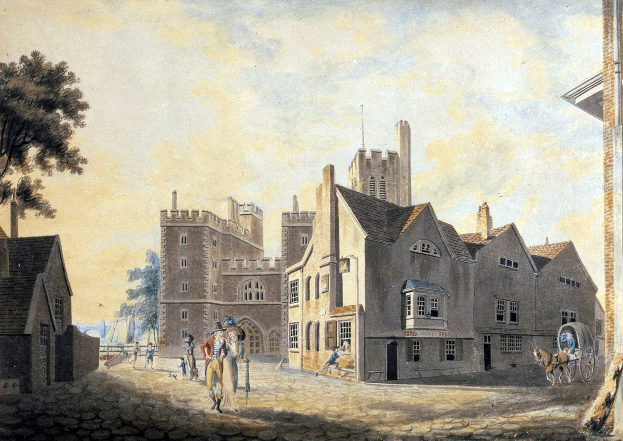
Turner was only 15 when he executed this work: it was his first piece to be displayed at the Royal Academy's annual exhibition in April 1790.
Horse Ferry Lane is the road on the right. The gatehouse of Lambeth Palace is directly ahead. The ferry-landing is to the left of the house immediately at our left, out of picture. At right-centre we see a nice-looking pub - The Swan, and we see a swan depicted on the pub signs outside. We can imagine stepping into Turner's shoes, buying a pint and resting our feet for a while on one of those benches to soak up the warm evening sunshine outside the tavern. All in all, we have a clear sense of an airy, unspoiled Lambeth in 1790.
This sense is even stronger in the next image, of the same location, painted circa 1800 by an anonymous artist. It is Lambeth Fair on a fine spring day. There are giant swings, probably nice nice things to eat for sale, and it looks like a great day out for the folk of Lambeth:
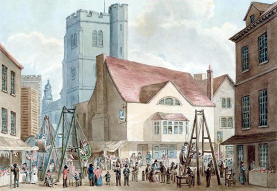
This contrasts interestingly with the photograph below, taken by photographer William Strudwick, sixty years later, in 1860.
You couldn't hold a fair at the crossroads of Fore Street and Horse Ferry Lane any more - it was hemmed-in on all sides by buildings too close to each other:

And when Strudwick turned around and pointed his camera the other way, as we see below, he gives us more insight into the development which Lambeth has experienced during the previous 60 years.
The turning to Horse Ferry Lane is just visible with the kerbstone turning left in the foreground. All charm has evaporated. Poverty is in the air. People were dying of cholera on Fore Street in the 1850s. You can barely swing a cat:
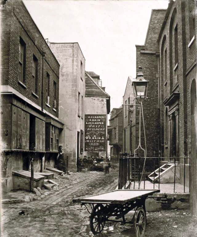

The photograph above was taken from the viewpoint of the green arrow in the map below:

The industrialisation of Lambeth is clearer in the c1864 photograph below, taken from the viewpoint of the yellow arrow in the map above, on the newly-built Lambeth Bridge.
The location of the charming old Swan pub lies immediately behind Wentzell's boat builders and Doulton's Drainpipe Wharf:

In 1746, when Rocque's map was drawn, some light industry existed in Lambeth; boat-builders yards, a starch manufactory. There had been potteries in Lambeth for centuries and the 'Pot Houses' evident on Rocque's map below were engaged in the manufacture of stoneware of all types from plain old drainpipes to colourful domestic pottery. The most famous pottery, as we see in the photo above, grew and evolved and merged in the 1800s into Doultons.
Glass-making had also been practiced in Lambeth since the early 1600s. There is a Plate Glass House at the south end of Rocque's map at Vauxhall, which had been established by the Duke of Buckingham in 1670 as a licensed monopoly, employing Venetian experts to make large mirrors.
The glass factory belched vast quantities of intense black smoke which is why Buckingham chose to locate it outside of the populated part of London in 1670:

But at the time of Rocque's map, Lambeth was still patently a village, entirely separate from London; a ribbon of old houses along two parallel streets on the east bank of the Thames:

In the engraving above, we see two of the windmills which used to inhabit the flat marshy Lambeth landscape. The picture shows us a Thames foreshore lightly occupied by wooden sheds, boat yards, dwelling-houses and... trees. These are notably absent in the industrial landscape which was to follow.
This is a good moment to bring in our next map, which was printed in 1753 by The Gentleman's Magazine to show the proposed new roads which were going to be built in south London.
South London?... Well, we are used to the convention that north must always be at the top of the map, no exceptions, but in 1753, this rule was less strict. The Gentleman's Magazine chose to put south at the top of their map, so it all looks a bit topsy-turvy to us. Lambeth is apparently on the wrong side of the Thames:
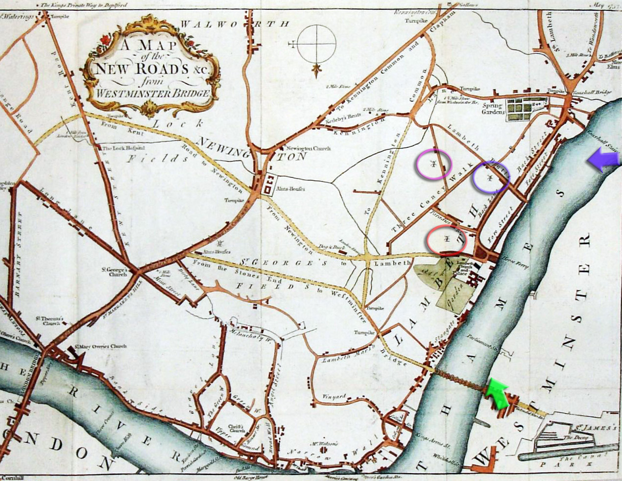
There were many windmills south of the Thames, but the draftsman who created the map above chose to indicate the position of three of them, presumably the biggest ones, which I have circled. It looks likely that the artist who drew that 1750 Lambeth windmill-landscape stood from the viewpoint of the blue arrow and looked at the mills picked out in blue and purple in the map.
We also get a clear view of the windmill circled in red, near Paradise Row, as it had been depicted in 1735 by artist Bernard Lens, as we see below. For this mill to be visible behind Lambeth Palace, Bernard must have drawn his picture from a viewpoint near to Westminster Hall, at the point of the green arrow in the map above.
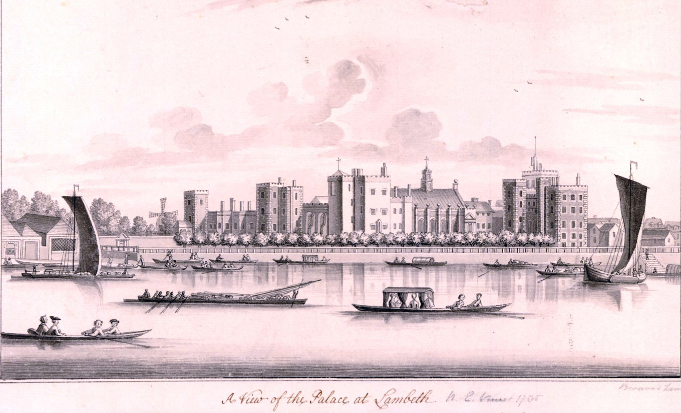
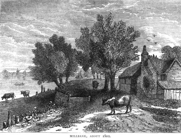
As we saw earlier, at Millbank, things are even more rustic... again a Lambeth windmill, an unidentified one, is visible on the other side of the river:
Maps are wonderful. In our chronology, the next one is from a pocket Atlas, Fifteen Miles Around London, a booklet published by the cartographer John Cary in 1786:

This map is useful because it gives us more context of the Partleton family. At the date this map was drawn, 1786, the Partleton family are living in the green circle, in Westminster. They won't be in Lambeth until the full expansion gets going there; not for 35 years yet.
So we move on in time and we come to Richard Horwood's most wonderful, magnificent, sumptuous map of 1799.
If you told someone today that Lambeth and Southwark are not parts of London, you'd get a funny look, quite rightly. But in 1799, they thought differently. Anything south of the river was Southwark, not London. And Westminster was a separate city, a twin city. It, also, was not London. Horwood's title plate is quite specific on the matter: Plan of the Cities of London and Westminster, the Borough of Southwark, and Parts adjoining:

Information about Richard Horwood, who is a complete hero, is thin. His date of birth is around 1758 and he died aged about 45 on 2nd October 1803, in Liverpool, completely skint as a consequence of his London map undertaking. But what an undertaking.
Ten years in the planning, meticulous, frustrating and arduous in its surveying, Richard's intent, which he fully achieved, was no less than to draw every house in London. Every alley, courtyard, hovel, field, shop and factory. Every stable. And to record every house number, where they existed, which for the most part they did. And for the map to be geographically accurate. It's breathtaking:
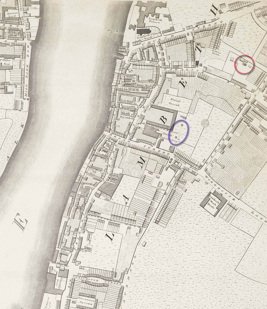
Note that in 1799 there are still no bridges at Lambeth or Vauxhall, but Lambeth has more than doubled in size from Rocque's map of 1746, spreading eastwards from the original two roads; there are new roads and a lot of new houses. The glass mirror factory is already gone, replaced by housing in Glasshouse Street. The windmill on Mill Street / Juxon Street is circled in red, and one - or both - of the circular structures ringed in blue may be the windmill on Lambeth Butts. The windmill on Gray's Walk is not apparent; I'm sure Horwood would have shown it if it were still there.
If you look at the detail in the map, and imagine Richard's surveyors crawling all over every property with their instruments and measuring tapes, in the back gardens, the fields, the closed courtyards, the posh residences, to all of which places they were often denied access, you can imagine how difficult this task was.
Naturally, during the course of his project, Richard went broke and had to borrow money. One very large loan was from the Phoenix Assurance Company - £500, a large amount indeed in the 1790s. In return he dedicated the map to the Phoenix. We'd call it a sponsorship deal and there were probably strings attached.

It is in this year of 1799 that Thomas Partleton's (b c1736) grandson Benjamin Partleton was born. 23 years later he becomes the first Partleton to move to Lambeth.
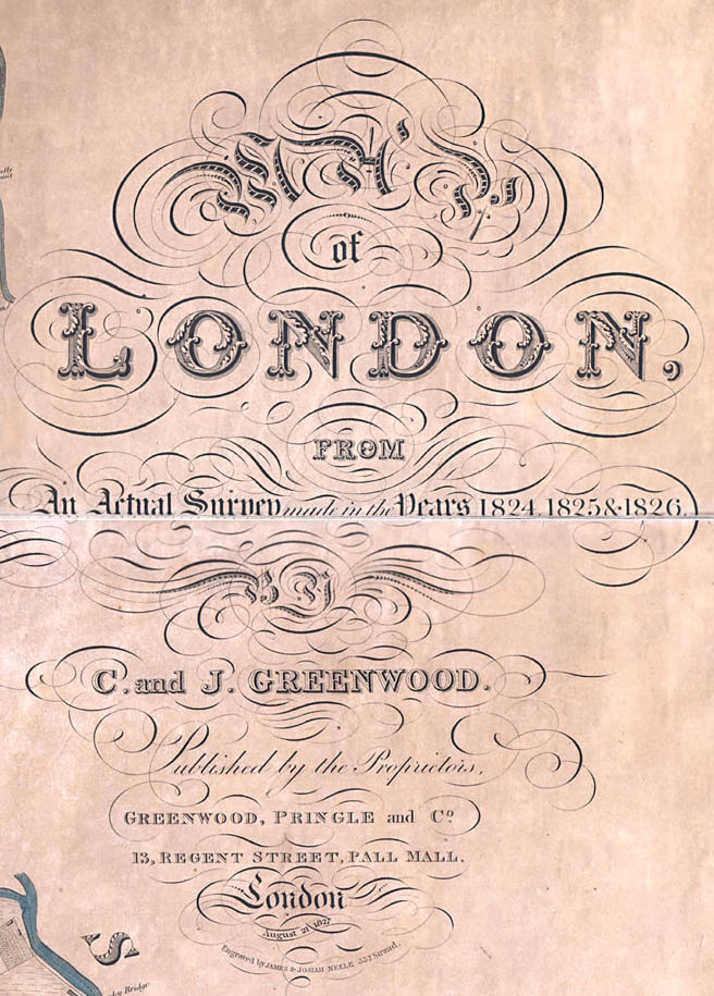
The next map, the Map of London from an Actual Survey made in the Years 1824, 1825 & 1826, surveyed by Christopher and John Greenwood and published on 21 August 1827, is interesting because it was surveyed just a year or two after the aforementioned Benjamin Partleton (b1799) moved south of the river to Lambeth.
The mapmakers were no longer drawing a distinction between London and Westminster and Southwark as separate entitities. Now the plan of the metropolis is simply a Map of London:
The population of Lambeth at this time was exploding. The following is from The History and Antiquities of the Parish of Lambeth by Thomas Allen, published in 1822:

From the above we see that over a period of 44 years from 1778 to 1822, the number of houses in Lambeth has increased six-fold. The number of people has increased even more than this.
The first event we see on record in Lambeth is the marriage of Benjamin Partleton (1799-1843). He married Mary Ann Greenwood (no relation to the map-makers Greenwood!) on 29 July 1822 in St Mary-at-Lambeth church.
One year later, on 18 June 1823, Benjamin's first child, Mary Catherine Partleton, was baptised:

The baptism took place at the church of St Mary-at-Lambeth which we saw in the background of that painting of Fore Street:

The church is circled in turquoise in the map below.
On the above parish register we see the first recorded address for a Partleton in Lambeth; the first of many: Union Street - these were relatively new buildings, circled in blue in the Greenwood map of 1827 below:
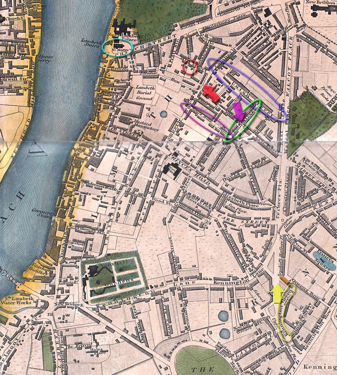
There was now more industry; distilleries; bone works; a 'mustard manufactory'; but Lambeth was probably still quite pleasant. Note also that there was finally a bridge at Vauxhall, bottom left, built in 1816:
Little Mary Catherine Partleton whom we saw being christened in 1823 above, died just seven months later in February 1824. This is absolutely typical of the high infant mortality of the time:

Baby Mary's abode at the time of her death was a different one to that of her birth: John Street, circled in green in the 1827 map above.
We have a surviving photograph of John Street taken from its junction with East Street, at the viewpoint of the purple arrow in the map: it's the road on the right in the 1960 picture below:

The buildings on the corner were built post-1827 as they are not evident in the Greenwood map. The style of these low-cost, low-rent houses is typical for Lambeth. No front garden, not even the tiniest one. Just step straight out onto the street.
Benjamin and Mary's abode on John Street was quite new but it was low-rent, low quality. Rented accommodation; and we find that it is very common policy for all of our Lambeth Partletons over 100 years to move house with bewildering frequency. Why move house when your new house is just 50 metres from your old one?... It's got me stumped but I suppose that it must be for a better price or for better conditions. Maybe they had short leases.
Maybe they moved for a better view... step into their shoes...

The above painting (by Henry Pyall) of the windmill near Lambeth Walk was painted from the point of view of the red arrow in the map below; very close to John Street.
The painting was executed in 1820, so it's exactly how the windmill must have looked to Benjamin in 1824. You could hardly miss it. We can see St Mary-at-Lambeth Church and Lambeth Palace in the distance.

It's the windmill circled in red in the map below:

The windmill is very clear in Horwood's 1799 map below, circled in red:

Though the windmill was definitely still standing, Greenwoods' mapping in 1827 was not as meticulous as Richard Horwood's had been 30 years earlier. The windmill was on the south side of Mill Street, in the red circle in the map below, though it's not apparent which building is which:

You might think this was an unsuitable location for a windmill... after all, there were no longer cornfields in Lambeth.
Below we see another windmill in 1780; this is a perfect illustration of how much Lambeth changed in 40 years. The scenery of 1780 is idyllic, birds wheeling high, the Thames in the distance with sailing boats. A man and his dog out for a walk, chatting to his neighbour...
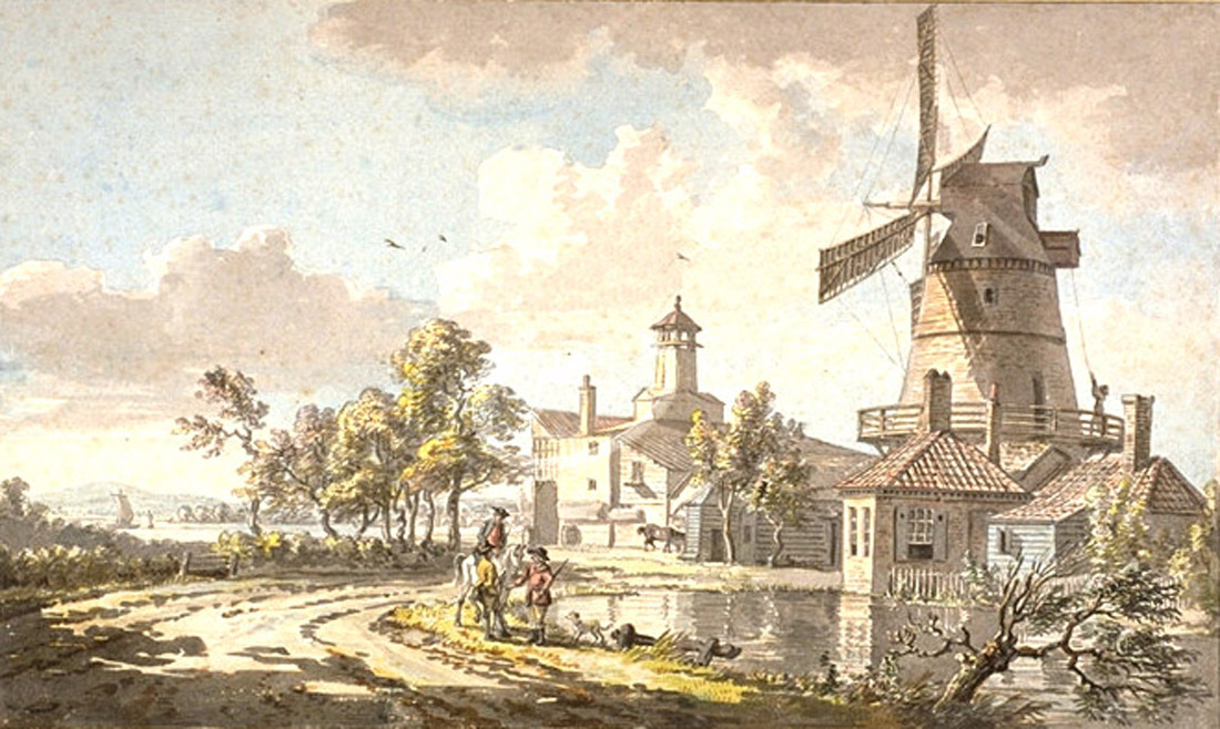
A closer view of the same windmill was painted by artist Paul Sandby in the 1750s or 1760s:

From its all-brick construction, we can see that the windmill in the picture is clearly not the same one which we viewed earlier on Mill Street. The Mill Street windmill may be the one which we can see in the distance at the extreme right of the picture.
According to the British Museum, the mill in Sandby's painting was located on Gray's Walk, circled purple in the map below:

Gray's Walk was even closer to Benjamin Partleton's house in John Street:

But Benjamin probably didn't see the windmill on Gray's Walk because I'm pretty sure it was demolished long before 1824 when he lived in the area. I can't find this windmill as a recognisable structure on any map, before or after 1824.
Another illustration of the semi-rural character of Lambeth in 1825 is the picture of Kennington Green below, painted by artist John Hassell:

John Hassell stood at the point of view of the yellow arrow in the Greenwood map below. The streets where Benjamin lived in 1823 and 1824, Union Street and John Street, are somewhere near the vanishing point of the road straight ahead.

Let's have another look at that nice watercolour:

The cottages on the right are Cumberland Row. These were depicted in more detail 30 years later, in 1855, as we see below:
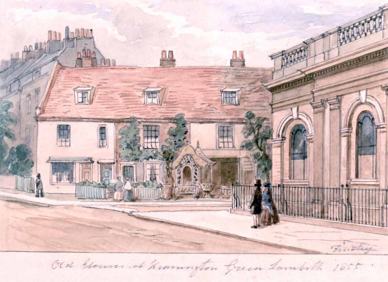
These cottages on Cumberland Row were also known for two centuries as the Plague Houses. That's because when they were being built in 1666, the unfinished cottages had been used as an emergency morgue for plague victims awaiting burial. The cottages are now long gone, demolished in Victorian times.
The artist of the the watercolour painting above is good old J. Findley whose sketches of London in the 1850s have been so useful in the Partleton Tree. Sadly Mr Findley never signs his work with his first name so I can't be more specific in his credits.
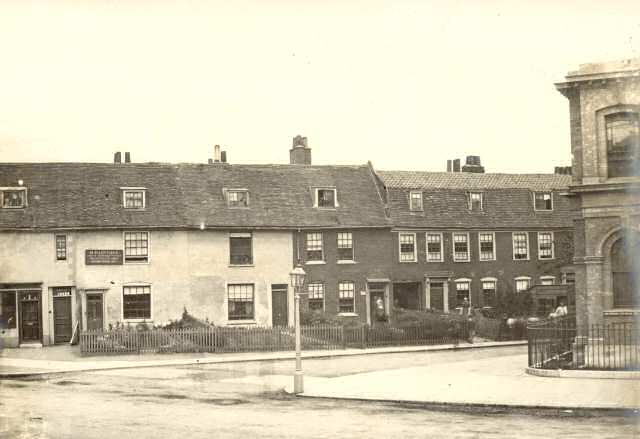
Below we see the same cottages in a photograph taken 5 to 10 years after the painting; and we might remark that Findley (and also Hassell) had used some artistic license with the shrubbery to brighten up their paintings. Never trust paintings; artistic license. To be fair, I also distrust old monochrome photographs which rob images of their colour and create what might be a quite incorrect cast of drabness. The world was not really black and white in Victorian times. They also had blue skies and flowers.
Let's bring back John Hassell's cheery, colourful 1825 painting again. Blue skies and flowers:

There's a signpost on the green. It's The Cock public house, complete with cockerel on the top, as observed by Partleton Tree correspondent Lance Mytton, who sent us an excellent scan of a booze flask from this very pub.
It's somehow satisfying to reunite the image of flask with the image of its long-lost home:
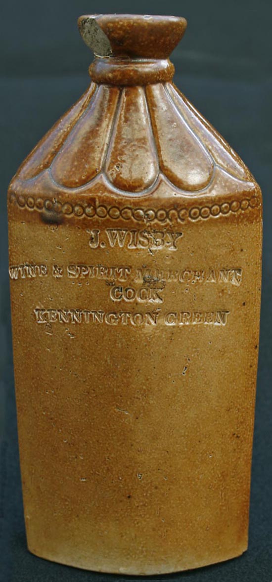
Was this pot cast in a Lambeth pottery? It seems likely.
The publican of The Cock, as named on the jar, is John Wisby, the son of a Lambeth auctioneer. Below we see John Wisby at home with his family in the pub in the 1851 census:
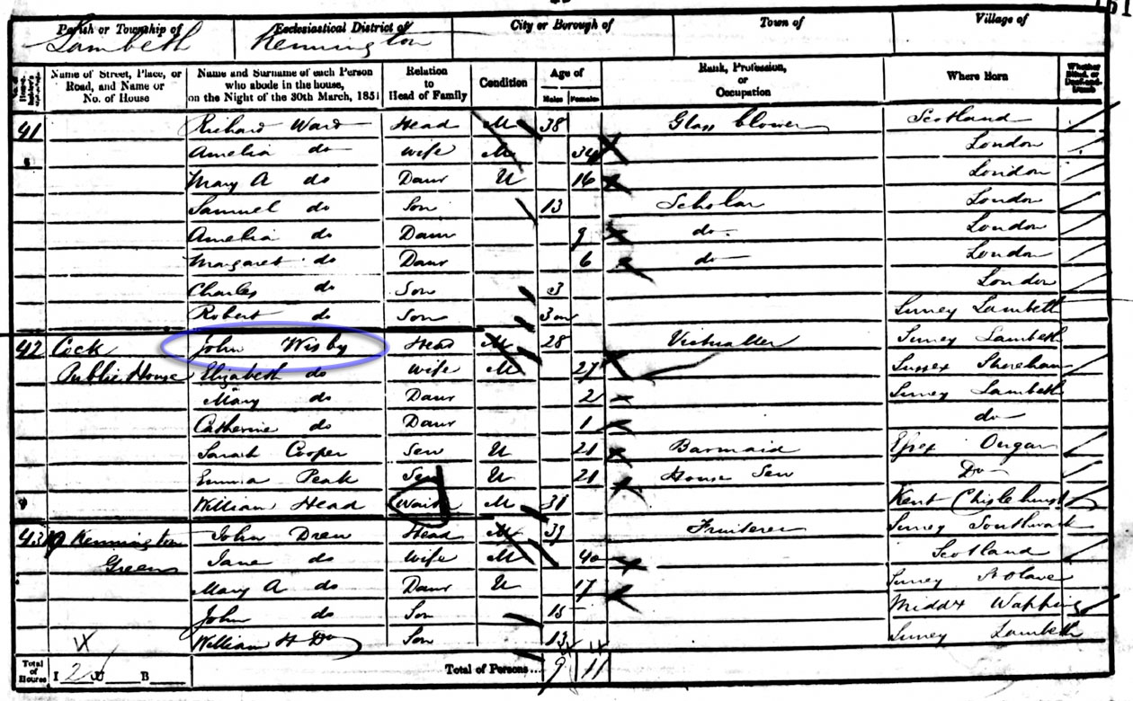
Sadly, John Wisby's wife Elizabeth was already a widow, running the pub on her own, by the time of the next census in 1861.
To give us the full picture of old Kennington Green, here's a montage of Hassell's and Findlay's paintings which I just couldn't resist photoshopping:

What we see above is the transition of Kennington In the early 1800s. We can still clearly sense the character of the old village green, with its horse trough and village pub, but the main road northwards is already completely lined with houses - and it's not going to stop there.
The population of Lambeth had already trebled between 1800 and 1825 when John Hassell executed his painting, and Benjamin Partleton lived in one of the new houses on John Street.
But this is only the beginning... as at this point, it only soars ever higher and - just when you think it surely can't grow any more - the growth accelerates and the numbers climb higher and higher. It is quite staggering:
 Left: First data point is from The History and Antiquities of the Parish of Lambeth; from 1801 to 1891 the data is from censuses
From here on, Lambeth is now becoming densely industrialised, desperately overcrowded; the gulf between the wealth on the northwest side of the River Thames and the poverty on the south side is widening.
Dirty and polluting industries are able to flourish on the south bank when they would be rejected elsewhere. The affluent in Lambeth are fleeing to more genteel areas, and the poor are flooding in, drawn by cheaper rents.
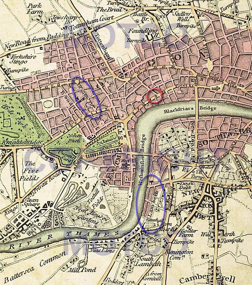
In the 1840s, railway mania reached Lambeth.
The existing services of the London & Southwestern Railway, coming up from Southampton, had been built in the 1830s but terminated at Nine Elms, a mile or so south west of Lambeth, which we see at the bottom left of the map below. Passengers then had to disembark and be taken by steam boat up the Thames into London... clearly inconvenient. An extension of the line through densely-populated Lambeth to Waterloo station was proposed in 1845 and the railway company experienced little difficulty in selling stock and using the capital to buy up vast quantities of land and slum housing for its new speculation.
In this 1862 map by Edward Stanford, we see the new railway, highlighted in yellow, scything though Lambeth. Every east-west road in the old borough is cut in half:

It was of course inconvenient that tens of thousands of poor people would be displaced, and that miles of shadowy arches would disfigure the landscape for the next 150 years (as can still be witnessed today), but nothing would stop railways in the 1800s. The owners of the slums - the church and the ancient London Companies - were indeed very happy to let go of the crumbling houses which were frankly an embarrassment, in exchange for lots of lovely cash.
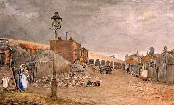
Below we see the new railway arches in 1848, not yet covered with soot, at the site of the 'Ragged School', a charity school for the poor, on Doughty Street - seen from the direction of the blue arrow in the map above. This painting on the left is dated 1848; the new school was completed in June 1851. By this time, Benjamin Partleton (b1799), though he had died in 1843, has numerous grandchildren in the Lambeth area, and since they are all unequivocally poor, it's eminently possible that some of them at least occasionally attended either this school or its predecessor institution at Lambeth Palace:
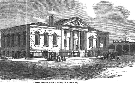
There are two large classrooms – one for boys and one for girls. The Ragged Schools were 'calculated to accommodate about 800 children' and that this had taken 'many hundreds from a state of filth and misery and raised them to one of honorable independence.' At the Lambeth Ragged School's opening, Lord Ashley declared that, 'There is no reason whatever why Lambeth should not rescue itself from the present disgraceful opprobrium which attached to it,' and then, 'Let the great basis of all Ragged School teaching be true sound evangelical Protestantism.' (Illustrated London News, June 1851)
We see in the background of the 1848 picture above that the tower of the old windmill remains, but it has lost its sails and thus is presumably no longer in use as a mill. Also worthy of note is that people still keep pigs and chickens in urban Lambeth.
The former location of the windmill is, unsurprisingly, exactly at the junction of Windmill Street and Mill Street (nowadays called Juxon Street), close to the route of the new railway, and it is suggested in the article below that the windmill was knocked down to make way for the railway line:
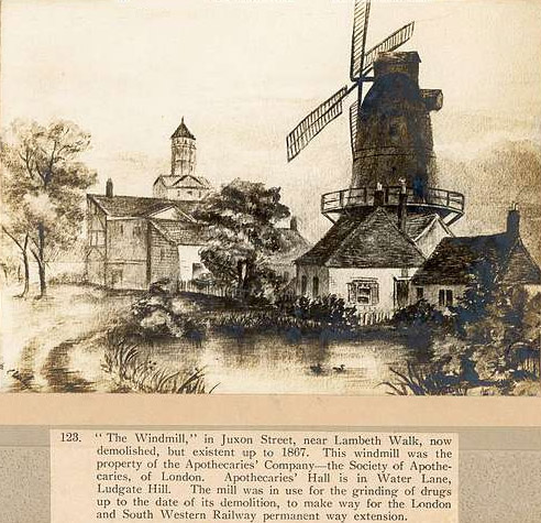
Actually, I'm sure the above article, which is held at Lambeth Archive, is hopelessly riddled full of errors. Firstly, the windmill in the picture is quite obviously not the one on Juxon Street aka Mill Street, but is definitely the one which the British Museum cites as being on Gray's Walk.
Secondly the Juxon Street mill was not in the way of the railway line, but was east of it, as we can see it circled in red in the map below, which is Horwood's 1799 map overlaid on Stanford's 1862 map:
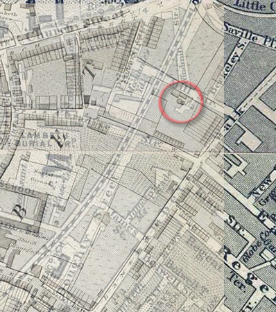
Thirdly, the railway was completed in the 1840s and if that demolition date of 1867 is right, that also contradicts the claim that it was demolished for the railway.
Let's hold that thought, of 1867, for a moment, and have another look at William Strudwick's c1864 photograph taken from the new Lambeth Bridge, wherein I believe we can see what looks like the old windmill tower at the point of the red arrow:
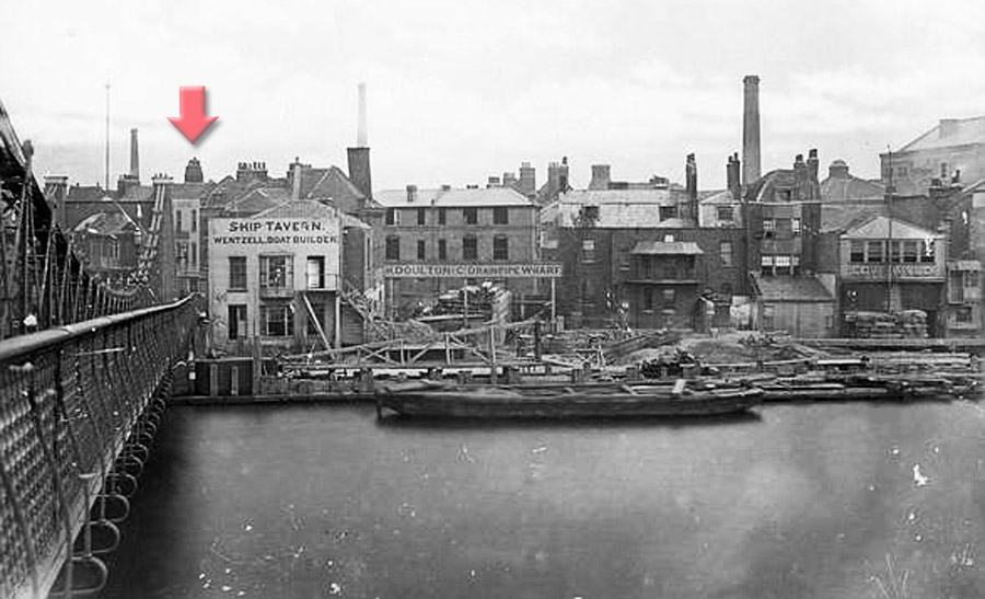
Fourthly, the mill [on Gray's Walk] was indeed owned by the Apothecaries Company, but I think it's a leap to assume that it must therefore have been used for 'grinding drugs' which I have seen quoted a few times. The ancient Livery Company of the apothecaries owned lots of land and buildings in Lambeth - they were merely the fat-cat landowners. Does one really need a giant windmill to grind drugs? I suspect not.
Ok, that's enough railways and windmills. Between 1800 and 1850, Lambeth lost its innocence; it metamorphosed from rural idyll to industrial slum, and, further, by 1850 was a slum riven by a railway. Any Partleton who grew up to witness these changes was probably bemoaning how much better things used to be in the 'old days'. The scene is set for another great upheaval, probably much needed.
Lambeth was built on low-lying marshes. The Thames would annually burst its banks on the spring tides, and flood the whole mess:


The picture above shows the flood of 1850, seen from the point of view of the yellow arrow. Just behind the houses directly ahead lies the home of James Partleton (1806-1873) in Dukes Head Court, which has no drainage or fresh water. What we should bear in mind here is that the Thames at this time is London's sewer. (James' daughter Sarah had died the previous summer aged 4, of cholera, from drinking Thames water).
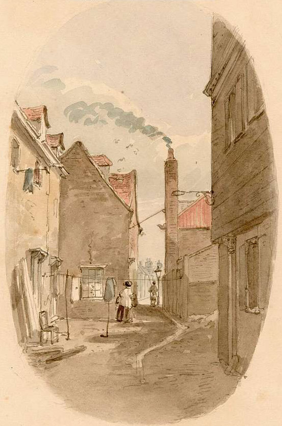 Left:
Duke's Head Court in 1850
James' house - one of those in the picture above - during the flood is two feet deep in water that smells of sewage.
We get some indication of what happened James Partleton's residence from a book Street Life in London published in later Victorian times by Adolph Smith and John Thompson:

In chapter five, the authors describe the aftermath of a Lambeth Flood:
'...another, a few paces further on, occupied by a widow, her son, and daughter. In no land, savage or civilized, have I seen a human abode less attractive and more filthy. The mother, who goes out "charing" [ie a cleaning lady] had seemingly neither the time nor the opportunity to render her apartment habitable. It was at her own invitation I followed her, as she said she had something to say to me. At a loss to conjecture what her communication might be, I made my way along a dark passage to a small doorway, and stepping over an accumulation of turnip-tops and mingled garbage, entered a room measuring about eight feet by ten feet. The walls were begrimed by smoke, and such portions of the floor as were seen were black and damp. The tidal overflow had registered its rise by partially cleansing the walls to a height of four feet, and by leaving the paper hanging in mouldy bags around... On a dark unwholesome bed lay a heap of ragged coverings, bestrewn with some articles of tawdry finery, and on one corner sat a little girl, whose bright dark eyes shone through a mass of matted hair. A broken chair was propped against the wall, near a chest of drawers warped and wasted by the water. The fire burned with a depressing glimmer, as fitful gusts of foul air found their way through a heap of ashes on the hearth: over the mantelpiece hung a series of small photographs, making up the collection of family portraits of husband and children who had passed away.'
Frankly, from our own investigations, the home of James Partleton, many of whose children died of dread diseases, may not have been much better than this.
In the photograph below, from the same book, we see a Lambeth "rag store" owned by Mrs Rowlett whom we see standing in her shop doorway. This shop collected second-hand items for resale and was located on Broadwell street between Waterloo Station and the Thames. We might call it a junk shop, but in the modern fashion it was also a recycling centre for paper and rags. The Rowletts made a good comfortable living from their business.

The Rowletts were also flooded out, as described by Mrs Rowlett:
"The water has taken us down a bit, and the last midnight flood was too much for my old man. He has now severe congestion of the lungs. Had it not been for the shop-boy, our losses would have almost been beyond repair. The boy was on the watch, and in time to enable us to save a few things: he appeared below the window, shouting, 'The tide! the tide!!' We knew what that meant and saved all we could. Our heaviest loss was made four years ago. It was so heavy we had to part with our horse and van to keep things going."
The Victorians knew that a change was required, something to hold back the river, to clear the slums, and to enable an ambitious new underground sewer system to clean up the Thames. A grand plan was drawn up. Between July 1866 and November 1869, most of the buildings; slums; potteries; boat builders' yards; bone-crushers; soap manufactories and everything else between Princes Street and the Thames were demolished to make way for the new riverbank frontage called the Albert Embankment.

But this page has surely gone on long enough...
The changes brought about by the building of the new Albert Embankment were so far-ranging that it deserves its own page for a later date.
If you enjoyed reading this page, you are invited to 'Like' us on Facebook. Or click on the Twitter button and follow us, and we'll let you know whenever a new page is added to the Partleton Tree:
Do YOU know any more to add to this web page?... why not send us an email to partleton@yahoo.co.uk
Click here to return to the Partleton Tree 'In Their Shoes' Page.
